Support this website by joining the Silver Rails TrainWeb Club for as little as $1 per month. Click here for info.


This website has been archived from TrainWeb.org/bayshorehs to TrainWeb.US/bayshorehs.

Delchamps Junction

Aerial photo of Delchamps Junction, circa 1940.

Delchamps was located about 4 miles south of Fowl River, and just to the east-northeast of the intersection of Rock Road and Bellingrath Road. The station was located between the tracks at the north juncture of the wye, and had an angled platform which followed the curve heading toward Kauffman and Coden. It is described as being on the same floor plan as the Theodore station.

Seen in this aerial photo, the junction no longer has a leg heading toward Alabama Port, and it cannot be determined when this was removed. It was present in 1916 when the ICC conducted their survey.

Notice also in the lower right-hand corner of this image can be seen the bridge through the Narrows, on the Alabama Port branch.

Enlargement of Delchamps Junction

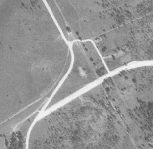
In this enlargement, notice the small cluster of trees at the north frog point of the wye. This would closely approximate the station's placement inside the wye.

The arrangement of the roads today is slightly different. Bellingrath Road was realligned with an extension of the southern portion and a curve before reaching Rock Road.

Topographic map of Delchamps Junction.

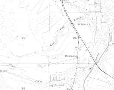
Compare the larger photo at the top of this page with the topographic map segment at far right.

ad pos61 ad pos63
ad pos62 ad pos64


Support this website by joining the Silver Rails TrainWeb Club for as little as $1 per month. Click here for info.