


This website has been archived from TrainWeb.org/brettrw to TrainWeb.US/brettrw.
Updated: 07/02/2005

Mileage to major cities and other points of interest from the southern entrance at Moapa. Los Angeles, CA (LAX) 336 miles (SW); Reno, NV 441 miles (NW); Salt Lake City, UT 379 miles (NE); Las Vegas, NV 51 miles (S); Phoenix, AZ 355 miles (SE), Caliente, NV 78 miles (N).
*** Major floods at the beginning of 2005 really decimated the ENTIRE wash. Much of the railroad and nearly all of the access roads were damaged. All bets are off right now on the info provided below. See this link for pictures and a bit more info.***
.
Overview for the Whole Wash
Who: Union Pacific. What you'll find: The Meadow Valley Wash (MVW), is a very remote railfan location. The roads are very rough and primitive and the proximity to civilization limited. SO, there are definite things to prepare for if you plan to make a trip to this area. 1. First and foremost a good map, preferably a topographical map. I use Delorme's Nevada Atlas and Gazetteer. ( Large, red, paperback, map style book available at any good bookstore, or stop at a Wal-Mart / Target in Vegas, they all carry them.) With atlas in hand, you'll find it hard to get lost once you're in the wash, but if for any reason you need to take a side road you'd better have a clue where it leads and how far you're gonna go to get to wherever it leads. 2. FILL your gas tank in Caliente to the north and Moapa in the south. This is the ONLY gas for 80 miles, don't get caught with a low supply of the stuff. 3. A truck is a definite from Carp south to Moapa. It doesn't necessarily have to be a 4X4, mine's not, but a car just won't have the clearance you are going to need to get through the wash. BE AWARE... I have gotten several flats in the southern portion of the wash. Don't go unless you have a good spare on board. I carry a full size spare, and the smaller "donut " just to be safe. North of Carp is A-OK, even for a moped if you wish. Heck the first 20 miles or so south of Caliente is paved. 4. The time of year is very important. If you plan a summer trip, get your vehicle serviced first! Any overheating this deep into the desert could be disastrous. Have at a minimum, 2 gallons of water for your car. 5. Read carefully... I would bring at least 1-2 gallons of water per human, per day. Please trust me when I say it will be VERY HOT and VERY DRY everywhere in the wash. ( Especially south of Carp.) 6. If you have an emergency chances are that someone will be along in a few hours. The locals use the wash frequently and I see folks on a regular basis, especially north of Carp. It is a bit more lonely to the south, so be aware there.
When to go: The best time will definitely be the spring. Longer daylight hours without the extreme heat. The vegetation is in full bloom, although fairly sparse. The weekdays will be busier, and Sundays are generally rotten. Very few trains. MOW crews will be found in the wash at anytime, and unless you get really unlucky they should be in places where you can get around them. By that I mean driving. On the southern end the road is single lane and often impassable to all but one vehicle. Be prepared to back up. It may be necessary. Remember some of the roads in here are UP's private road, don't be an dork and bug the MOW crews.
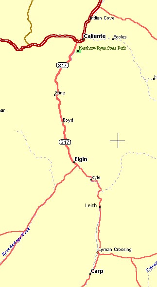
Overview - North Section ( Caliente to Carp )
What to expect: The north section of the MVW is definitely the more awe inspiring location. This area would be highlighted by the red rock sandstone and tree lined wash that has water in it year around. There are even 2 beaver dams in this section of the wash! You'll see some awesome cliffs and fire reds and oranges, probably the brightest colors I have ever spotted, and I have been all over the southwest. The roads in the north are in great shape, and passable for every vehicle. There are farms and campgrounds, a state park and 6 tunnels that the trains pass through. By far this area is the best for those who want to avoid the harshness of the desert. How to get there: You can get to Caliente by going north out of Las Vegas on I-15 and exiting at US 93 (exit 64) and turning left. The UP main is right behind you and you are 130 miles from Caliente. If you have a truck and want to shave off 30 miles try the Kane Spring road that leads too Elgin from US 93. It's 30 miles of fairly decent dirt and will get you to the tracks at Elgin, then north on 317 to Caliente, (this is the same road you'll follow south if you come in on US 93.) If you are coming form the north (Utah), get off I-15 in Cedar City, UT and take SR 56 (exit 59) and head west. 95 miles later you'll arrive in Caliente, and along the way pass Modena, UT, and the UP main. There are also roads from St. George, UT., Ely and Wendover, NV. Once in Caliente, follow the tracks south out of town. Basically, US 93 south and turn right onto State Route 318. This is the main trail. Side roads get you closer to the tracks, as they weave back and forth in the canyon, but be prepared to cross the stream... without a bridge. Amenities: ( I'll be checking out some of these in the future, look for an update mid-summer 2001. There are several local motels in Caliente. Food is limited to local restaurants, there is no McD's or the like. Gas is limited to a Chevron station, and not much else. It is a small town, but you'll be ok.
Overview - South Section ( Carp to Moapa )
What to expect: The southern
end is the most barren section of the wash. Seclusion has its privileges
though. You'll be on a primitive one lane dirt road here, that is literally
right beside the track the entire way to Farrier, a siding just outside
the wash. There are actually 2 roads and even 3 in the wider parts of the
wash. These can be used to get around MOW crew vehicles and are BLM ( Bureau
of Land Management ) roads. The way to know is if it isn't right beside
the tracks, you are on federal property, which to the best of my knowledge
is PERFECTLY LEGAL. There are forestry markers on these roads and NO, NO
TRESPASSING signs. These roads are not maintained like the UP access
road though, and will often join the UP road in narrow canyons and across
deeper sections of wash.
The landscape here is very different from that
in the north. You'll find that the mountains are more rounded and have
less cliffs. There is no color, except a light brown, and there is more
desert vegetation ie: cactus, sagebrush and mesquite shrubs, and almost
no trees and grasses like the northern section has. You'll like the stark
contrast of this section however, and how the trains stand out against
this backdrop. How to get there: There are 2 ways to get here.
First continue on RT. 318 south at Carp, and the dirt road will lead
you here. If you are coming up from Las Vegas, exit I-15 at Moapa,
exit # 90 which is RT. 168. Head west ( the only way you can go ), and
you'll reach the UP overpass in about 3 miles. Turn North (Right) and you're
on the MVW road. It follows the track fairly close until you get to Farrier
and then it is right there the rest of the way to Carp. Amenities:
There is even less in Moapa than in Caliente. A gas station or two and
that's all. Be prepared to stay in Caliente, or return to Las Vegas when
the days over. Of course out under the stars with the coyotes is nice!
North Section - Caliente to Carp
.
|
|
|
|
|
|
|
|
|
Tracks follow RT 317 all the way through the wash. Use RT 317 to access everything from Caliente to Moapa.
|
||||||||||
| Etna is a small siding that appears to not get to much use. In the era of 6000' and 7000' unit coal and intermodal trains it's not hard to see why. The mountains here are nice and provide a nice backdrop to the trains. Not much else here to speak of , so lets move on... |
|
||||||||||
| Stine is in what I call the tunnel district.
Starting at Stine there are 6 tunnels between here and Kyle, just 20 miles
away. 5 of those 6 tunnels are located before you get to the next station
at Boyd, just over 4 miles away.. There are even 2 that are close enough
that almost all trains will pass through both at the same time, since they
are only 4/10 ths of a mile apart.
The tracks hug the mountain side here, and it's obvious that the surveyors were trying to keep the tracks elevated enough to avoid minor flooding along the wash. The ruggedness of the location is one of its major appeals, but also a large drawback. I have yet to find a way across the wash to get trackside. So without crossing the stream, I don't know that it is possible, and to date I haven't grown a large enough set to try in my 2 WD truck. Those of you with 4X4, be my guest, but remember it is a long 12 mile hike back to Caliente for help. Stine might be the 2nd best location along the Caliente Sub, the first is definitely our next stop...Boyd. |
|
||||||||||
| Boyd is my favorite location. The long
siding encourages frequent meets, and the scenery is breathtaking. Boyd
is at the heart of the Rainbow Canyon, and it isn't hard to see where the
name came from. The sheer cliffs of red, orange, yellow, and pink sandstone
is a sight to behold. There are so many cool rock outcroppings that I'm
confident you can get multiple shots without redoing the pictures. There
are so many things to see, some are literally impossible to include a train
in.
One drawback is this is definitely an afternoon location. The sun comes up right over the cliffs and will completely wash out any picture taking prior to its passing overhead. Be aware that you'll be likely to only catch 2-3 trains during the afternoon, unless you get lucky of course. Plan on other areas of the wash, but get here by afternoon, you won't be disappointed! |
|
||||||||||
| Elgin is an old ghost town. There is a
small ranch here and an old school house that I think is now a museum.
Never been in so I don't know. The tracks here get hidden by the cottonwood
trees that line the wash, but where they emerge at Elgin is really cool.
See the photos for this area, it's hard to explain. Elgin is also a junction
of sorts. The paved road RT 317 becomes dirt and the road split into 3
trails roughly. You'll want to follow the trail to the left as you approach
the siding. (just turn toward the tracks). If you continue south along
317, it will lead back out to US 93, 37 miles away. This road can be used
by cars, but it is bumpy.
Following the road along the tracks, leads to some camp sites and on toward Carp and Moapa. Cars can go as far as Carp, but after that you'll need something with a little more clearance. Anyway, Elgin is nice, on to Kyle. |
|
||||||||||
| Kyle is another colorful spot along the Caliente Sub. The mountains here have a great purple and yellow hue and the tracks make a sweeping turn that passes along the front of this display of colorful sandstone. Kyle also has the 2nd longest tunnel along this sub, at 1226'. The road will follow very close to the tracks, but is also very wide and therefore easily negotiated even when a train is approaching. Other places in the wash are not this way. |
|
||||||||||
| Leith is probably the hardest spot to access.
The track follow the mountains very closely and the main road veers far
away (at least far in terms of the rest of the wash), probably over a mile
at the wider spots. Leith is the northern extremity of what I consider
the dividing line between the north and south sections of the wash. Leaving
Leith headed south you enter into a broad gently rolling valley. The vegetation,
topography and road condition all change in this valley, by the time you
get to Carp, you might as well be in a totally different place than you
were 10 miles earlier.
Gone are the colorful sandstone mountains of Boyd and Kyle, the tunnels are over too. Here begins a more typical desert scene, with cactus, sagebrush and sparsely scattered trees lining right at the wash's edge. Often the wash dries up this far south, with only sporadic emergence from various springs along the trail. The one factor that remains the same though is the overwhelming sense of beauty that this area displays, albeit different from the area just covered. So read on, lets head for Carp. |
|
||||||||||
| Carp is a long siding that starts immediately
after crossing the wash for the umpteenth time. The siding was once the
scene of a large steam servicing area, water and coal tower, if my understanding
is correct. All that remains now is the clearing where this once stood.
There is also a small service track, that often has MOW equipment being
stored between uses. Carp is also at the junction called Lyman's crossing
(which I believe was named after my wife's great, great grandfather, Amasa
Lyman, an early Mormon pioneer, who helped settle San Bernardino.)
Anyway, any of the sidings south along the wash here are very similar, but all have a unique flavor, so lets explore. |
South Section - Vigo to Moapa
|
|
|
|
|
|
|
Tracks follow red road all the way through the wash.

|
||||||||||
| Vigo is located at the narrowing of the wash as it winds down toward Galt. The tracks turn very east /west here and give morning eastbounds a great nose lit possibility. This section of the wash is almost always dry, and there are several locations where you'll be glad that it is, because the road actually follows the wash for several hundred feet. |
|
||||||||||
| Galt is probably my favorite location along the southern stretches of the wash. The wash narrows into a narrow, winding canyon, with sheer cliff walls and really neat rocky crags. There are 3 - 4 bridges across the wash here and the canyon scenery is a great sight. This is probably also the worst section of road in all of the wash, so use caution. |
|
||||||||||
| The tracks emerge from the Galt area straight, flat and with a higher posted speed. You'll also encounter you first grade crossing of the tracks since leaving Carp, 17 miles ago. The trains here will usually leave you in the dust. I learned on my very first trip to the MVW, that there is no such thing as "chasing a train" through the wash, well at least once you get off the paved road at Elgin. My best advice for Hoya and pictures, is to find a spot on the hillside, where the tracks turn into or out of the long straight away and get trains before they pick up speed. The east end of Hoya affords particularly nice views of the train winding back into the wash. |
|
||||||||||
| Rox has a great bridge and a large pond
underneath it, that usually is full of waterfowl, and migratory ducks and
geese. They all seems to know it's here. The trains will emerge from the
west, along a VERY narrow stretch of land, sandwiched between the wash
and the cliffs. The road and tracks are so very close at this point that
this is not a location to be caught with a train arriving. While this stretch
is short (200 yards or so), it happens to be the best spot to catch westbound
trains pulling through the bridge. Leave you truck at the bridge crossing
(very safe location) and hike the 200 yards back to get the shot. You'll
still be very close to the train, but at least have a little room to maneuver
yourself. Watch for dragging articles, cause you'll need time to scamper
out of the way if there are any.
Rox has other locations where the road is much wider, but the scenery is fairly generic at best. At the west switch looking south, there are some of the coolest rock formations you'll find anywhere in the wash. These pillars are massive, and run in succession one after the other, all along the plateau. It is cool. Eastbound trains will arrive nose lit in the long summer days, and allow for the trains to be photographed with this backdrop, I'm still working on getting a shot. Try it out, they are neat. |
|
||||||||||
| At Farrier you'll be officially out of the wash. It wanders off to the east to join up with the Muddy river near Moapa. Farrier is great for morning and evening trains, both east and west. This is because broadside shots from both side of the track have some really neat mountains in the background. The hills and plateaus around this area really lend themselves to nice picture taking. The trains increase speed significantly and don't slow down until the get toward Las Vegas. Fortunately the road improves dramatically over the condition it is in the wash, and therefore you'll be able to get here in a car if you wish. |
|
||||||||||
| The siding at Moapa is the scene of a large UP presence. There is the small branch line to Logandale here, a coal electricity plant with the RR delivering the coal, and a few MOW buildings that almost always have somebody hanging around them. The town of Moapa is 3 miles or so back toward the interstate, but the post office sits on the hill overlooking the scene below. The overpass will also provide views and you can also access an overpass looking into the coal plant. A little exploring will go a long way around here, as there is much to be found. |